DigitalGlobe has trained cameras from its five orbiting satellites on the Gulf of Thailand.
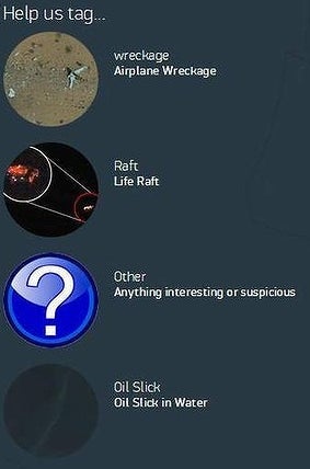

It is asking volunteers to log onto its Tomnod website and search for clues.

A computer algorithm will be used to determine whether users start tagging certain regions more than others.
Luke Barrington, senior manager of Geospatial Big Data for DigitalGlobe, told ABC News: "For people who aren't able to drive a boat through the Pacific Ocean to get to the Malaysian peninsula, or who can't fly airplanes to look there, this is a way that they can contribute and try to help out.
"We'll say, 'Here are our top ten suspicious or interesting locations. Is it really an aircraft wing that's been chopped in half or is this some other debris floating on the ocean? We may not be 100% sure, but if this is where I had to go pick a location to go looking for needles in this big haystack, this is where I'd start."

It’s not the first time the site has been used for such a purpose.