

The origins of the devastating floods that swamped the southern Plains over Memorial Day weekend lie half a world away.
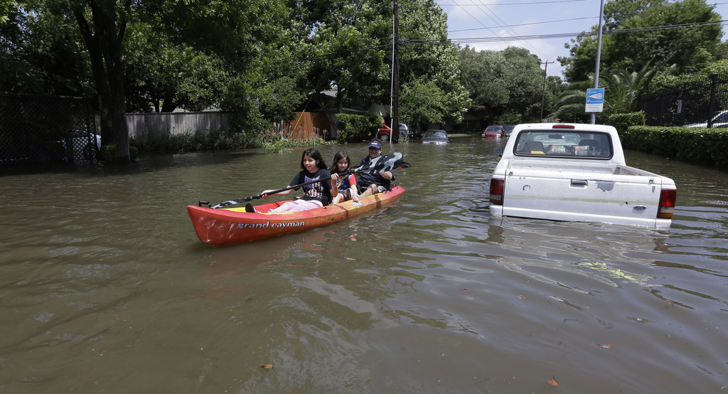
Over the weekend, torrential rainfall and flooding destroyed roads in Oklahoma and Texas and a deadly tornado swept through a Mexican town. A dam failed. More than 30 people across two countries are dead. But it began with something much more subtle and much more wonky: a warm band of air north of the equator known as the subtropical jet stream.

The subtropical jet stream normally carries moisture to Central America, producing rain on the lush forests of southern Mexico. But over the last three to four months, particularly warm water along the equator has nudged it further north, climatologist Bill Patzert told BuzzFeed News. When the jet stream moved into the Texas and Oklahoma region, it mixed with more warm air from the Gulf of Mexico and clashed with cold air from Canada, producing severe storms.
"Did El Niño get Houston?" Patzert, who works at NASA's Jet Propulsion Laboratory in Pasadena, California, said. "In a way, because it did push that subtropical jet stream farther north. And it zeroed in on Houston."
El Niño is a phenomenon in which warmer-than-normal water along the equator in the Pacific Ocean alters the wind patterns that carry moisture to North and South America, as well as other parts of the globe. An El Niño can range from weak to strong, and one effect can be intensified storms that move into California directly from the west. Perhaps most famously, El Niño fueled storms that walloped Southern California in 1997 and 1998.
In the Great Plains, spring storms are common. But several meteorologists from the National Weather Service who spoke with BuzzFeed News agreed that the severity of the recent storm systems appeared to have been amplified by a developing El Niño event.
"In an El Niño year we tend to get into that pattern where we have a stronger subtropical jet," Josh Lichter, of the NWS Houston-Galveston office, said.
The result has been astonishingly powerful storms. In Texas, May was the wettest month on record statewide, besting the previous rainfall total by nearly an inch. Texas State Climatologist John Nielsen-Gammon cited El Niño as a contributing factor in the storms and noted that areas near Dallas received 20 inches of rainfall this month.
“It has been one continuous storm after another for the past week to 10 days in several regions of the state," Nielsen-Gammon reported. "It has rained so much that the ground just can’t soak any more moisture into it, and many creeks and rivers are above flood stage.”
Records have similarly been smashed in Oklahoma, which also just had its wettest month ever. So far in May, the state has received an average of 12.95 inches of rain — more than two inches above the previous record that was set in 1941.
Jeff Evans, also of the weather service office, and Kurt Van Speybroeck, of the National Oceanic and Atmospheric Administration, further pointed to a low pressure trough that contributed to the storm's location and severity.
"It’s not atypical to get a lot of rain," Evans said. "It’s atypical that it’s been so persistent."
The origins of the storms matter because much of the West is suffering from severe drought, with many hoping El Niño will offer some relief.
A year ago, a quarter of Texas was experiencing exceptional drought, the most severe of five categories. Nearly all of the rest of the state was seeing some level of water shortage. Conditions were even worse in the years before.
But as of last week, 70% of the state isn't experiencing a drought at all. None of Texas is currently in the two most severe drought levels, and the end of the drought altogether may be near for the Lone Star State.
“About 15% of Texas was still in drought as of last week,” Nielson-Gammon said, “but at this rate it won’t be long before even the driest parts of the state are drought-free.”

Animation of #drought improvement for Texas from May 2014 to now! #txwx #dfwwx
So could something similar happen in California?
Patzert described the Golden State's odds of a substantial storm event later in the year as "pretty good." But he also pointed out that along with badly-needed rainfall, Texas is being slammed with flooding.
"El Niño is a double edged sword," Patzert observed, adding that during the last major event in the late 1990s Southern California also saw flooding, mudslides, and property damage.
The ability of storms during El Niño events to alleviate the drought may also be limited. The upside of the recent rainfall in Texas is that depleted lakes, ponds, and water storage facilities have been filling up. But rain has fallen so quickly that much of it will also wash out to sea before soaking into the ground and replenishing the water table.

Another problem with El Niño as drought relief is storms are more likely to track into Southern California, but the state's water supply mostly comes from the northern half and is replenished by colder storms that move south from Alaska.
The result is that while the West may be headed for a wetter winter, the effects of that precipitation on the drought are very much up in the air.
"Those are the kinds of storms that we dream of," Patzert said, "but those are not El Niño storms."