
Uber is launching a free tool that will allow anyone to view auto traffic patterns and analyze travel times based on customizable routes and time periods.
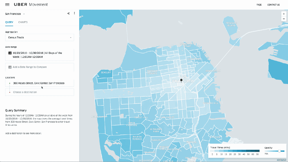
The tool, called Uber Movement, extrapolates traffic trends based on Uber trips in a given area to provide travel times to and from specific destinations based on the date and time of day you enter. It can also show whether rides took more or less time than average. The ridehail giant says Uber Movement will begin as an invite-only tool for city planners and researchers, but will soon be available to the public.
“We are making something available that we know has a concrete value for transit authorities and other people in that space,” Andrew Salzberg, head of transportation policy at Uber, told BuzzFeed News. “Being seen as a credible partner and being part of the long-term decision-making, and thinking through how cities collect data and make decisions, is something we want to do.”
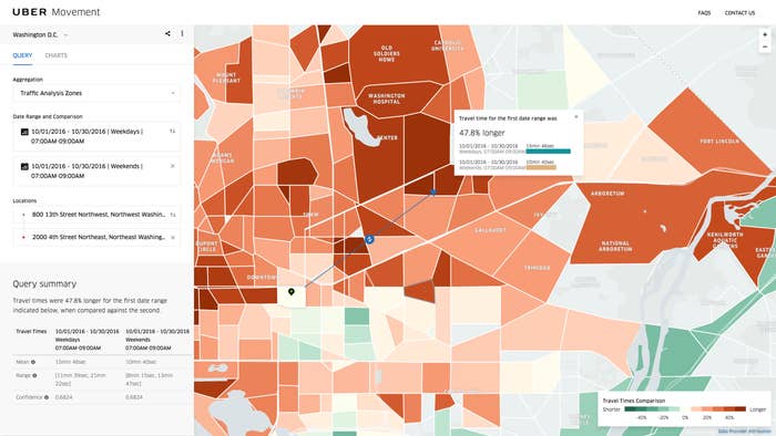
Using Uber Movement, a tool akin to Google Trends but for traffic patterns, users can enter locations and date ranges to measure the traffic impact of, say, a lane closure or major highway disruption, a metro shutdown or a new road. The tool could benefit urban planners or other people looking to analyze travel patterns, for example, in a hackathon. (Other similar tools used by urban planners are not free.)
In the last year, Uber has launched partnerships with transit agencies across the country to subsidize rides and extend its reach. With that in mind, the tool works in Uber’s favor: It could help the ride-hail giant make a case to local governments that by subsidizing UberPool, a city could alleviate congestion in certain areas.
“We believe that the way we operate, around sharing vehicles and working with transit, is ... ultimately is going to have a positive effect on the city,” Salzberg said. “We think we’re helping make cities’ lives easier.”
Uber Movement will start off with three cities: Washington, DC; Manila, the capital of the Philippines; and Sydney, Australia. To build out traffic patterns, the ridehail giant uses its own anonymized trip times and car speeds as a sample size.
Last year, Uber began sharing traffic data with Infrastructure Partnerships Australia, a research group there. Salzberg, who studied urban planning and worked at the World Bank as an urban transportation specialist before joining Uber in 2013, said making the data free and public could help city planners or others who might be interested in traffic patterns for research purposes.
Stephanie Dock, research program administrator at the District Department of Transportation in Washington, DC, said the agency has been in conversations with Uber about the new tool for several months. She said learning more about traffic patterns through Uber’s data would help inform the agency’s work to reduce congestion.
“Uber captures a particular portion of the market,” Dock said. “They have a lot of vehicles on the road. Looking at what’s going on there does help us get a better picture.”